The Importance of Restoration in Tackling Rapid Mangrove Degradation
By Dzimar Akbarur Rokhim Prakoso, Remote Sensing Officer YKAN
Mangrove forests play an important role in tackling climate change. This is good news for Indonesia, which has one of the largest areas of mangroves in the world. But, as with other areas of the country threatened by deforestation, Indonesia's mangroves are at risk of disappearing. Indonesia has lost more than 50% of its mangroves in the last 30 years, earning it the dubious distinction of having the world's fastest rate of mangrove depletion (FAO, 2007).
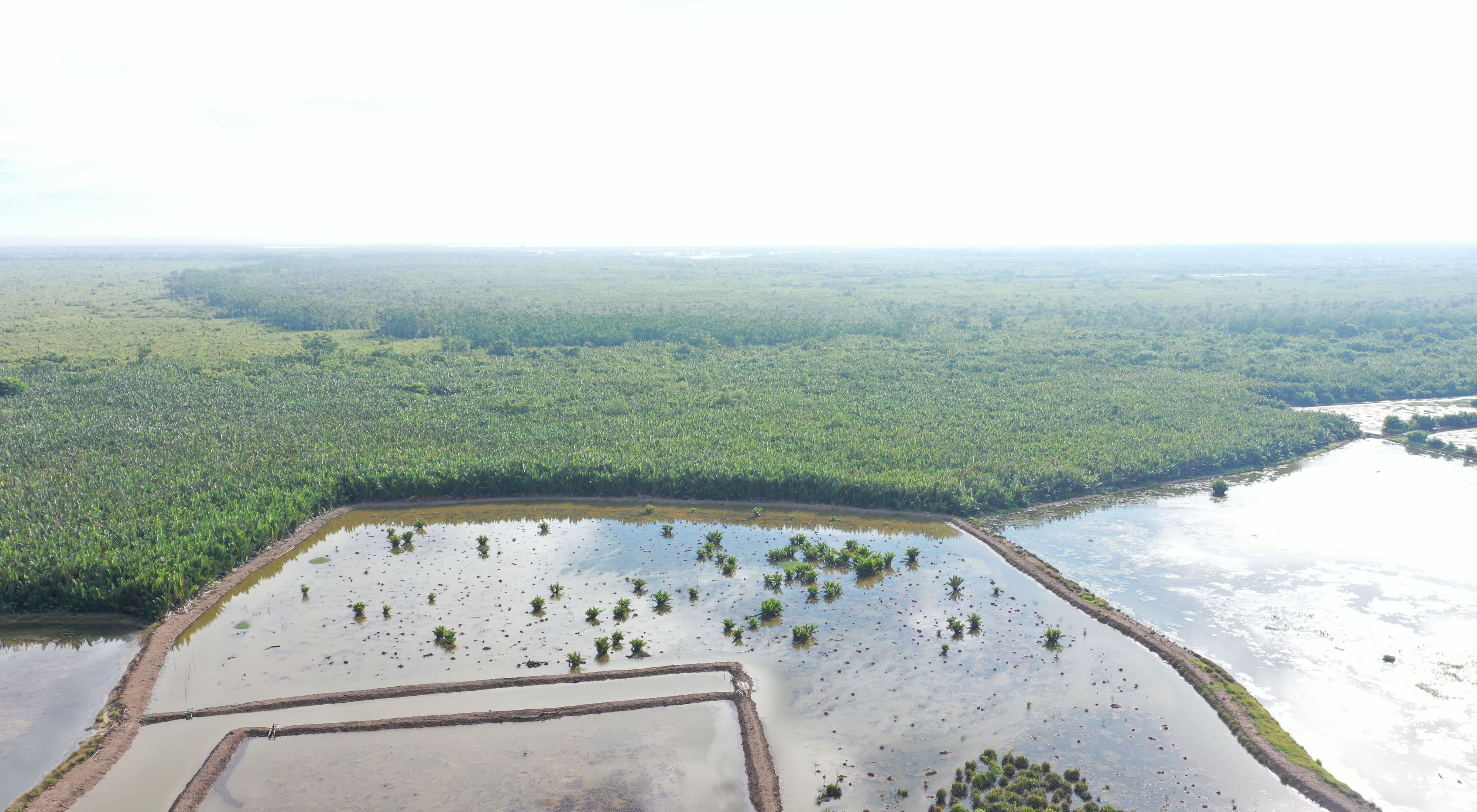
East Kalimantan Province has Indonesia's third largest area of mangroves, behind Papua and Riau. These mangroves are under great pressure from land conversion for shrimp and fish ponds. This conversion mostly occurred during the period 1970 to 2000. It peaked in the 1990s, affecting the coastal regions of the Mahakam Delta, North Penajam Paser, and Paser.
The initial cause of this change was the relocation of the population. In-depth interviews with government officials, shrimp farmers and mangrove managers indicate that migration laid the foundations for new and small communities that eventually transformed into well-established villages, such as Muara Pantuan and Sepatin in Kutai Kartanegara Regency
As villages became more permanent, residents converted mangroves into ponds, often using a traditional tool called a "kong" (shovel-hoe). Illegal logging also impacted mangroves. Mangrove forests were also severely damaged by rampant illegal logging, which had become a massive economic activity, especially in the Mahakam Delta and Balikpapan Bay. The illegal logging continued until around 1970, when the "new order" government came to power and introduced mandatory forest concessions.
Analysis of mangrove cover
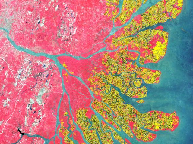
The Nusantara Nature Conservation Foundation (YKAN), through its Indonesia Oceans Program, conducted a multi-temporal spatial analysis of mangrove and shrimp ponds in East Kalimantan using satellite imagery, such as Landsat 5 TM for data acquisition in 1990, Landsat 7 ETM+ for data acquisition in 2000, and Sentinel 2 for data acquisition in 2019.
Based on the history of mangroves in East Kalimantan, 1990 was identified as the beginning of mangrove deforestation, thus making it baseline data in this study. The period between 1990 and 2000 was recorded as the peak deforestation period in East Kalimantan.
Based on the history of mangroves in East Kalimantan, mangrove deforestation began in 1990, providing a baseline date for the research. Subsequently, 1990-2000 was identified as the peak period for deforestation in East Kalimantan, providing the date for researching the change process.
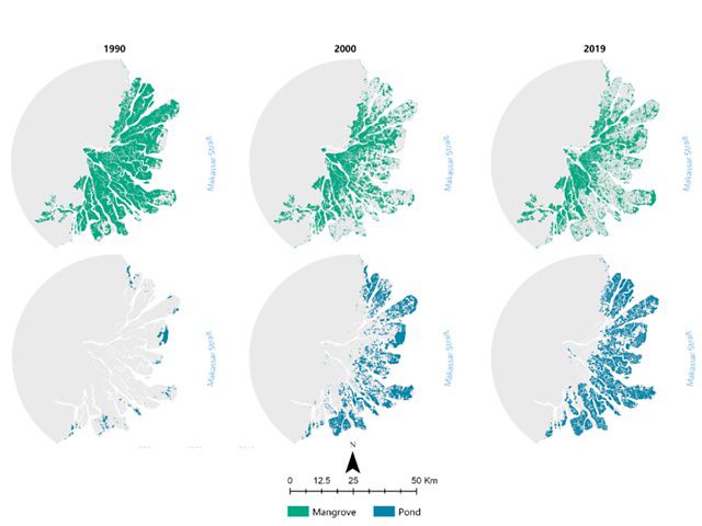
Satellite imagery can capture objects optically based on real conditions in the field, enabling the analysis and differentiation of mangroves and shrimp ponds. The entire mangrove habitat in East Kalimantan in 1990 covered 268,147 hectares. Between 1990 and 2000, it decreased by 15% and 5% from 2000 to 2019.

These findings reveal that the greatest mangrove land conversion occurred from 1990 to 2000, resulting in a total degraded mangrove area of 52,632 hectares, with only 215,514 remaining in 2019. At the same time, notable changes in shrimp ponds occurred between 1990 and 2000, considered the peak conversion period. An estimated 61,083 hectares, or around 70% of the total shrimp ponds identified in 2019, covered an area of 86,471 hectares in East Kalimantan Province.
In general, the expansion of shrimp pond areas continued during the 2000-2019 period, albeit at a drastically reduced intensity. The study results align with in-depth interviews regarding the pioneering areas for shrimp pond cultivation in East Kalimantan in the 1990s. These include at least the three following areas: the Mahakam Delta, measuring 5,462 hectares; North Penajam Paser Regency with 2,385 hectares; and Paser Regency at 852 hectares.
Mangrove deforestation will become more prominent in locations further away from the mouth of the Mahakam River and surrounding settlements. Most mangrove deforestation occurs in delta areas close to the coastline.

This indicates various conclusions, including the possibility that this period might represent a saturation point for aquaculture land conversion. It could also be associated with land availability and the impact of regulations or significant pressure on the rate of change.
The analysis of conversion clarifies the correlation between changes in mangroves and shrimp ponds in East Kalimantan. In general, the conversion of mangroves to shrimp ponds accounted for 65% of the total mangrove reduction observed in both the 1990-2000 and 2000-2019 periods, with the Mahakam Delta region experiencing the highest conversion level.
Approximately 80% of the mangrove changes from 1990 through 2000 in the Mahakam Delta were due to converting mangroves to shrimp ponds, while the remainder resulted from plantations, settlements, and damage due to land clearing. The smallest percentage of mangrove-to-pond conversion area in the 1990-2000 period occurred in the city of Bontang.
This analysis provides an important foundation for YKAN to develop mangrove restoration programs through the Mangrove Ecosystem Restoration Alliance and Shrimp-Carbon Aquaculture programs. Locations that have recently experienced a loss in mangrove coverage will be prioritized for restoration.
In addition, the methods used in this study are being deployed throughout Indonesia to help determine YKAN's priorities in implementing mangrove restoration programs. The restoration process itself must also find areas that can be potentially restored.
Acknowledgment
The data presented in this paper are based on an analysis conducted by YKAN in 2019. The authors thank the Caterpillar Foundation for funding this research through the YKAN's Indonesia Oceans Program. We would also like to thank the entire team from the East Kalimantan Provincial Department of Fisheries, Berau Regency Department of Fisheries, Kutai Kartanegara Regency Department of Fisheries, Balikpapan City Department of Fisheries and Penajam Paser Utara Regency Department of Fisheries for their support and assistance during data collection and field surveys.


