Simple Application Breakthrough, Facilitates Monitoring and Evaluation of Forest Restoration
Oleh Muhammad Rosidi, Spatial Planner YKAN | Musnanda Satar, Conservation Planning Senior Manager YKAN
Efforts to restore forest areas, reforestation, and tree planting have been carried out nationally by many parties, from the government and communities to the private sector. Based on the 2014-2024 strategic plan of the Directorate General for Watershed Management (DAS) and Protected Forest, Ministry of Environment and Forestry (KLHK), in 2019 alone, planting was carried out in an area of 395,169 hectares. With this area of planting, it is necessary to build a monitoring and evaluation system that can show the number, type, and growth of trees in detail.
Indicators of success of a forest area restoration activity, apart from being quantitatively in the form of the area of restoration, can also be seen qualitatively, such as the survival rate of plants, impacts on the site such as increasing forest density, animal food availability, improving water quality, increasing A healthy watershed (DAS), and the greater the benefits to the surrounding community. This indicator needs an application that ensures all indicators are measured on both the output and the resulting scale.
Application breakthrough
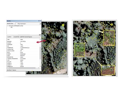
One of the materials for preparing the application is the presence of spatial data. Spatial data in developing this application is necessary because restoration of forest areas in the form of planting cannot be separated from space and time, the distribution of locations where planting points are located, and the time allocation for planting. The distribution of planting points and times is a reference for each monitoring activity and a form of transparency of planting realization.
Restore the area, of course, continues beyond planting activities. However, marking the plants (tagging) is also followed by completing regional location data, blocks, parcels, sharecroppers, types of plants, coordinates, and photos. This initial marking is the basis for the next activity, namely monitoring. Both planting and planting activities require an application.
Yayasan Konservasi Alam Nusantara (YKAN), through two conservation programs running in the Muria Mountains, Kudus, Central Java, and the Halimun Salak National Park (TNGHS), Bogor, West Java, is trying to build an application for monitoring and evaluating planting using an online platform issued by an international geographic information system software supplier company, the Environmental Systems Research Institute (ESRI).
The conservation program in Muria targets the restoration of an area of 700 hectares, while in TNGHS, it is 200 hectares. In these two areas, the tree planting process was accompanied by easy monitoring and evaluation tools to capture data, starting from the location of the planting points, tree species, community groups, and plant conditions.
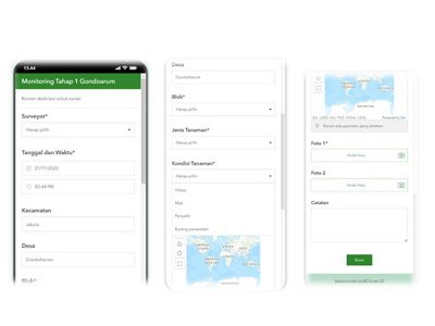
In the activities carried out in Muria and Gunung Salak, YKAN uses an application from ESRI, namely ArcGIS Survey 123, as a data collection solution using a simple but high-performance form so that the process of creating, sharing, and analyzing surveys only requires three easy steps. Although not the newest application, ArcGIS Survey123 meets the needs and is easy for ordinary people to use, considering YKAN. Considering that YKAN applies a community-based restoration approach, a simple application that community groups can utilize will be more effective.
Stages of Application Implementation
ArcGIS survey 123 has many criteria needed and can be implemented quickly. ArcGIS survey 123 is made based on Android and can be accessed via cell phones as the medium. The preparation stage is as follows:
1. Establish a logical framework
In this process, the researcher compiles the variables determined in an application, the order, and the relationship between data and information to be retrieved so that the user feels comfortable. The determination of this variable supports and ensures that the data collected is valid and has a strong correlation with the objective.
2. Trial system
Solicit input from the internal team and the community, as users, after conducting trials in the field.
3. Application usage training
In community-based restoration programs, training is a vehicle for increasing community capacity and transferring knowledge.
Analyze results and reports
Read the results of monitoring and discuss with stakeholders, especially the community, to find solutions to various problems encountered during monitoring as an effort to improve in the future.

Application usage training for the younger generation
Training on using applications as a means of capacity building and knowledge transfer to the community also fosters a sense of ownership of the activities they have carried out in forest area restoration. Society is not just an object of exercise but a subject capable of taking steps to improve the surrounding environment based on self-awareness.
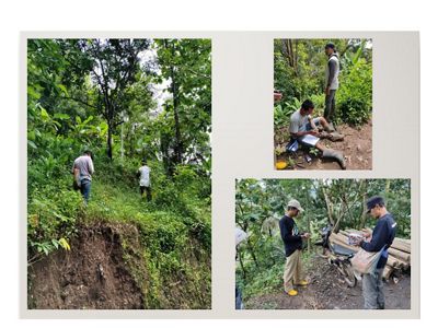
In this case, the involvement of young people in training is highly desirable. When carrying out the marking and monitoring restoration process, the younger generation will recognize and know the potential problems in the surrounding environment, especially their agricultural land.
After the training, they also discussed monitoring results in field schools to provide a more thorough understanding and develop the ability to analyze regional needs.
Implementation of monitoring with ArcGIS survey 123
Implementing marking and monitoring rehabilitation plants using the ArcGIS survey 123 application is more straightforward and accessible. The level of accuracy is also reasonable compared to other mobile applications. In this monitoring process, the involvement of farmers is a must because community participation is the primary approach in this restoration process. Monitoring activities with the application also increase the efficiency and effectiveness of time during the training.


Strengths and Weaknesses of the ArcGIS Survey 123 Application
Some views on the use of ArcGIS Survey 123 in the plant monitoring process are as follows:
- Application is simple in manufacturing.
- The application is accessible for farmers with just a short training.
- Limited user capacity is a problem, especially for farmers, because of the paid survey platform.
- The cellphone will heat up quickly if it does not meet specifications when managing large amounts of data (thousands of tags).
- To maintain the level of accuracy in the field, GPS is still needed as a control device.
Technology update via ESRI Field Maps
In the future, YKAN is considering using ESRI Field Maps—an application from ESRI with the latest and more sophisticated technology—in implementing restoration monitoring and evaluation. ESRI Field Maps is an application that combines the functions of data capture and editing, information analysis, and real-time reporting. This application can integrate functions, from preparing data retrieval formats, data retrieval processes, and online data storage using online ArcGIS and analysis functions to sort data. Of course, you can also display data online through the dashboard.
YKAN's activities with partners in the Muria and Mount Salak areas have become a valuable lesson that using technology in monitoring and evaluating forest restoration is a simple job that researchers, forestry experts, or geographers can only do. The community can carry out the data collection process through a short training process.
The key is to build a simple application, assembled and ultimately can be used to ensure the restoration process does not stop at planting but continues with the goal of restoring ecosystems and forests.

