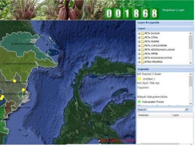
The East Kalimantan Plantation Office, in collaboration with the Nusantara Nature Conservation Foundation (YKAN), has built several online information technologies (IT)-based service systems. One of them was WebGIS, or digital mapping, developed in 2017. This application was designed to make it easier for the provincial, district, and municipal government offices to evaluate, educate, and monitor plantation companies. It was also created to help manage the spatial database of the East Kalimantan Plantation Office for regular updating and modifications, mainly since it can be accessed online. This application is also part of the effort to reach the mitigation targets for greenhouse gas emissions.
For the WebGIS programme to be sustainable, the East Kalimantan Plantation Office has conducted several activities to improve its human resources capacity. These activities include: (1) Collaboration with the Regional Development Agency (Bappeda) and the Ministry of Communication and Information (Kominfo) in developing a web infrastructure as a part of the central government's "One Data One Map" programme; (2) Training and dissemination of the online reporting information system (SIPKebun); (3) Online training and filling up of the Approval Letter for Oil Palm Seeds Distribution (SP2BKS) for Large Private Plantations (PBS) and cooperatives/communities; (4) More informative data updates; (5) Mapping of oil palm supply chain from plantation to shipping port to be input in the WebGIS; and (6) Web-based training for the geospatial information system at the provincial, district/municipal, and PBS levels. Several regional government organisations have managed to fill in and complete the plantation spatial data and information in their work areas. The public can already access the inventoried data.

Users who want to access WebGIS Perkebunan (Plantation WebGIS) can visit the East Kalimantan Plantation Office's website (https://disbun.kaltimprov.go.id) and then click on the WebGIS Perkebunan's thumbnail in the following web page https://geospasialkebun.kaltimprov.go.id/index.php/home. Then, users can retrieve a list of plantation commodities, plantation pests, and satellite imagery of plantation locations across East Kalimantan. However, users need to register first to access the data in more detail.
Moreover, the thumbnail for the Plantation Information System (SIP-Kebun) can also be accessed from the main page of the East Kalimantan Plantation Office. Typing on the following URL https://sipkebun.kaltimprov.go.id on an internet browser's address bar can also grant quicker access. This application aims to help Plantation offices at the provincial level in monitoring reports from large plantation companies. Based on the 2014 Plantation Law, plantation companies that have already pocketed a Plantation Business Permit must submit regular reports to the government, in this case, the Plantation Office. Hence, SIP-Kebun acts as a bridge between companies and the government to ensure the reporting process runs smoothly.

