“Drones” for Conservation: Monitoring and Evaluation of High Conservation Value Areas
Musnanda Satar, Conservation Planning Senior Manager YKAN
Not only used to capture stunning landscapes from a height, drones, now one of the mainstays in making audio-visual arts, also provide fresh air in the conservation world. Monitoring and planning of area management in large areas can now be carried out more effectively. Scientists/conservationists can also obtain up-to-date information and factual data to determine when issues require high urgency to be followed up immediately.
It is undeniable to know the actual condition of a location takes a long time, especially in a forest area that has a high density. Some sites are even still challenging to reach because of their remote location. However, with this drone, exploring hard-to-reach areas is no longer impossible. This drone can also carry payloads. On most drones, the freight is a camera for shooting. However, drones can also be used in conservation activities to maintain and spread plant seeds.
BioCarbon Engineering, for example, in 2019, the UK-based start-up used drones to spread 25,000 plant seeds in Australia, Africa, and New Zealand. The Conservation Drone Community also monitored orangutan conservation activities in Aceh in 2013. At that time, drones were used to count orangutan nests and map orangutan habitats. Yes, the prominent role of drones in conservation cannot be separated from their function in supporting and retrieving data for mapping.
Data accuracy and effectiveness
Drone applications for mapping have been developed and are applied in various fields. Several global-scale spatial data providers have also actively used drones, such as Google, which uses Titan Aerospace's drones to obtain real-time images that support Google Maps or other services.
In the world of conservation, drones are especially needed in digital mapping and GIS applications to provide a detailed description of an area that becomes a reference for monitoring, analyzing, and providing recommendations for the development of effective conservation strategies.
Drones are considered more profitable because they can provide high-resolution images and the latest spatial data faster, in contrast to satellites, which require the duration of taking pictures periodically within a specific time period. Mapping applications with drones in certain areas that are carried out regularly will also be much cheaper when compared to obtaining data through high-resolution satellite imagery with a resolution of less than one meter.
Besides being widely used to map orangutan nesting locations in Indonesia, drones in conservation also monitor forest areas, including reviewing concession management areas and getting an overview of the most recent land cover conditions.
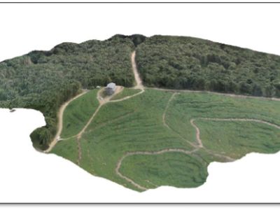
Drones can take data on current conditions in a wide range of areas, either in one broad landscape or in detail in one location. The captured drone image can be further processed to produce a three-dimensional visual display. This image can be processed with remote sensing software as primary data to build land cover maps and other layers.
Monitoring and evaluation of HCV areas
In carrying out conservation activities, Yayasan Konservasi Alam Nusantara (YKAN) also uses drones to carry out mapping activities, which have proven to be more effective—among other things, monitoring activities for Forest Concession Rights (HPH) management areas in a cooperation scheme with The Nature Conservancy, in the practice of Reduced Impact Logging (RIL) or environmentally friendly logging systems, monitoring protected forest areas, collecting land cover data for village forest activities, and monitoring of biodiversity in certain regions. Using drones was also made for monitoring activities in YKAN's working area in East Kalimantan, such as in the Sangkulirang Mangkalihat Karst area, in the Wehea Protection Forest area, as well as monitoring land cover around Merabu Village, Berau, to support village forest initiatives.
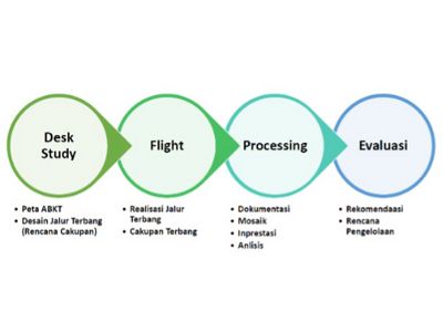
YKAN uses drones to identify and monitor high conservation value (HCV) areas. The approach starts from a desk analysis study, taking drone data, processing images, and concluding some of the inputs for the NKT evaluation (see Figure 3).
Meanwhile, monitoring activities can be carried out more effectively by using drone data. YKAN uses a small chopper drone that can be flown up to a height of 500 meters, although for mapping purposes, usually at an altitude of 100-200 meters, covering an area of up to 200 hectares. Based on drone data, monitoring can be more straightforward by taking samples according to drone capture conditions.
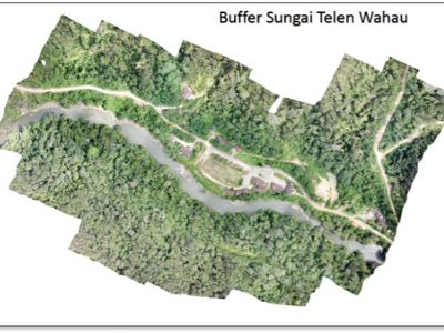
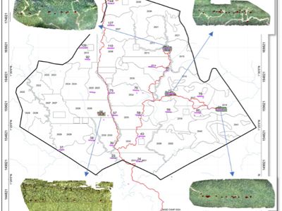
Figure 4 shows that the high-resolution images obtained from drone captures can provide a detailed picture that helps determine better sampling points without visiting the entire area.
Drones also allow further spatial studies, where the captured images can be processed using GIS software and remote sensing to determine the condition of land cover changes. Pictures taken with drones for mapping must be photographed vertically and are usually done with a specific grid to capture an area's overall image in a structured manner. These photos are then processed further and produce a photo mosaic that displays a broader coverage area. This image can be processed with various remote sensing software such as Drone2map or image processing software such as Erdas or Envi.
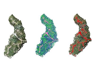
Figure 5 shows YKAN's analysis of identifying an area based on a combination of drone photo mosaics. The results of remote sensing studies can be compared with the land cover baseline in previous years and can be used as a baseline for systematic studies in the future. This study can determine land cover change, deforestation, or reforestation of the area under study.
Applications for the use of drones continue to develop along with the development of drone technology and photography, which allows drones to cover a wider area with better image quality, and high resolution. In the end, monitoring and identifying HCV areas will be more effective and have accurate data to be used as a reference for developing conservation program strategies.


